City of Bogota
Site Description
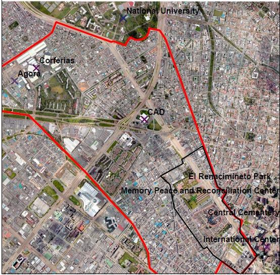
Bogotá is the capital and largest city of Colombia, located in the center of Colombia, on a high plateau known as the Bogotá savanna. Reencuentro is an important area of value for the city of Bogotá. It contains large public spaces and city-scale facilities, such as the Central Cemetery; El Renacimento Park; the District Administrative Centre; City Council; the Memory, Peace and Reconciliation Centre and “Corferias”, a large events venue.
Its articulating axis is found on 26th Street, where the north and south ends of the city meet and has an important historic and symbolic value. These are the reasons why it’s called Reencuentro (Reunion). This axis also connects the project to other facilities such as the National University and the El Dorado International Airport as the entrance to the city.
Environmental and Social Issues
The majority of the surface in the study zone is hard, with exception of the presence of the El Renacimiento Park, sidewalks and small green areas. There are not any NBS implemented in the study zone, although, there is a total of 6035 trees in El Reencuentro zone.
Accordingly, with the urban environmental classification of the city, developed by the Botanical Garden and Universidad de los Andes16, the case study is located in zone 3 (sub-urban 3.1). The zone is principally used for commercial and institutional proposes with a low vegetable density in comparation with the mean of the city. The low population density of the zone makes it desirable for the development of green areas. Mine while, the proximity to the main roads of the city and the industries represents high temperatures and high exposition to pollution and particular matter in the zone.
Although there is an extensive presence of green areas and trees in the study zone no NBS or bluegreen hot spots have been implemented. The use of the green meeting points identified is more related to the improvement of social cohesion in the study zone, than to the management sustaining regulatory services and self-regulatory potential of nature.
Meanwhile, the city had some advances in the implementation of NBS, as the Institution of Urban Development (IDU) of the city had more than 300 ongoing plans for the implementation of SUDs in the city. In terms of regulations, although the technical standards to the design of SUDs have been developed (NS-166), there is still a gap in the availability of professionals to ensure the use of suitable design process. There is also a lack of participatory strategies with the citizens to co-create public space and promote the consolidation of natural solutions to solve urban challenges of the city. It is also related with the lack of educational programs in the study zone for governmental institutions, academic institutions and citizens that allowed the communication between stakeholders to promote the NBS implementation.
Demonstration activities
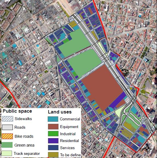
For the euPOLIS project case study, a smaller area was defined (51.4 ha). The current surface covered in the study area is divided by many land uses, such as commercial (2.68 ha), equipment such as schools, hospitals, meeting points and cemeteries (8.96 ha), industrial (0.46 ha), residential (5.69 ha), services that will be defined in the Master Plans (4.94 ha) and to be defined (2.38 ha). It also has 6.8 ha of sidewalks, 8.64 ha of green areas, 0.22 ha of bike routes, and 10.68 ha of main roads connecting the city centre with the facilities found to the east.
It is considered a strategic center of the city because it encompasses high level urban operations and interventions within its scope, related with public and occupational systems that define the land occupational model. However, it requires the implementation of public and private projects to ensure the best physical and functional conditions.
The potential development of the study zone is related to the Reencuentro project’s support capacity. Furthermore, this support capacity is in turn related to the relationship between the city’s functional public infrastructures, such as mobility systems, public space systems, equipment systems, patrimonial systems and public services systems; with current and future population, population density, potential buildings and land use conditions.
Related items

City of Lodz
City of Limassol
City of Belgrade